| Place |
 |
■Regular classroom □Computer room □Special
classroom □Gymnasium
□Athletic Field □Outdoors □Others〔 〕 |
|
|
|
| Type
of Lesson |
|
■Class □Group □Pair/Individual □Follow-up □Others〔 〕 |
|
|
|
| Phase |
|
■Introduction □Development ■Conclusion □Others〔 〕 |
|
|
|
| Main
user of IT |
|
■Teacher □Student □Others〔 〕 |
|
|
|
| Objectives |
|
□To introduce the topic ■To motivate
students ■As illustrative material used by the teacher □As illustrative
material used by the student □To master through repetition ■To present
a model □To recollect past experiences ■To compare □To examine what
has been done/studied □To provide second-hand experience □Others〔 〕 |
|
|
|
| Equipment |
|
■Computer ■Projector ■Screen □Electronic
Whiteboard □Visual Presenter □Digital Camera □Video Player □Internet □Digital
Contents □CD-ROM □Speakers ■Others〔 3D modeling software “Teddy” 〕 |
|

| Utilizing free software that allows the teacher to create
a 3D model by drawing lines with the mouse to visually present the different
stages of land formation and its features, the concept of contour lines
and other such information. |

Land Formation and its Features, How to Read a
Contour Map
Contents: based on curriculum guidelines
Content (1) Systematic geography of the modern world
A Natural Environment

To understand land features and the principles of contour
lines by watching a 3D model of the landscape created on the PC.

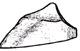
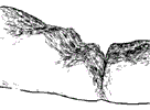
| (1) |
Show a 3D model of a mountain
summit with a projector. Rotate the model while demonstrating in real
time how land is being eroded by glaciers by reshaping the mountain. |
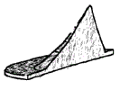
| (2) |
Project a 3D model of the seabed
and explain oceanic trenches and their relation to the plate movement
by rotating and scaling the model. |
| |
|
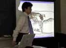
|
[Abstract]
The teacher is explaining the topography of the seabed by using a model created with 3D software. |
| |
|
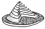
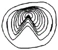
| (3) |
Create a simple 3D model of a
mountain and place it horizontally onto the computer screen. Write in
equally spaced horizontal lines. Rotate the figure so that the model is
being viewed from above to show the contour lines. Have the students understand
what contour lines are and check to see if their predicted landscapes
are correct. |
| |
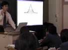
|
|
[Abstract]
The teacher is explaining about contour lines using a model created with 3D software. |
| |
|
| |
|

| It is recommended that you create a simplified landscape
model with its features emphasized for easy explanation. However, since
this does not provide an accurate model, actual pictures or videos of
landscapes should also be used to complement the lesson.
|
| Teddy should be used at the beginning and end of the lesson
and special attention should be paid to make sure students have a chance
to read a contour map on their own and to use their imagination to predict
the landscape. |

|